
Having spent 16 days in the South Island, it was time to bid farewell to the island and also to the rest of our travellers while five of us proceeded to the north island.
We flew in from Christchurch to Auckland, 757km away. We rented a MPV (or People Mover as it is known in New Zealand), a Toyota Estima for our 10-day trip. Starting from Auckland, we travelled south to Tongariro National Park before heading back north to Rotorua, then to Paihia.
Friends who have been to both the north and south islands told me that ‘if you have been to south island, you would not find north island attractive, it is much less scenic and you may not like it so much…’ Well, I was about to find out.
20091210
.jpg)

Auckland
We left Christchurch at 7:00am on Air New Zealand. Upon arrival at Auckland at 8:20am, the sky was overcast and it was raining. I made a call to our car rental company and within minutes, their representative arrived and took us to their office near to the airport to sign the contract, make payment and to collect the car. We were made to wait and were told that they were checking and servicing the car. That would take about 10 minutes, we were told. Ten minutes came and gone and another ten minutes and another…
With the gloomy weather and the wait, our extended holiday seemed to get on to a ‘bad’ start…
Finally we were told that one of the lights was not working and that they did not have spare units. We were given an alternate car (not equivalent of what we have paid for). We asked if there would be any compensation for all the inconvenience and was told that they would refund us for the first day rental. And they did. We were told that we could get the car (of what we had paid for) in the afternoon.
With that we drove off, heading for our motel. With the GPS, it was not difficult to locate it.
After checking in and having unloaded the luggage, we were all ready for some exciting time in Auckland and beyond. By then, the rain had stopped and things were beginning to look better and brighter. Our first stop was Mt Eden, followed by a visit to the Victoria Park Market.
While Mt Eden (Maungawhau) gave us a spectacular 360 degree superb view of Auckland, the Victoria Park Market was a let down.
(Auckland is punctuated by some 48 volcanoes and Mt Eden, at 196m, is the highest volcanic cone in the area.)
 Mt Eden area (above and below)
 View from Mt Eden (above and below few)
 Harbour Bridge across the Waitemata Harbour in the background


 The crater at Mt Eden
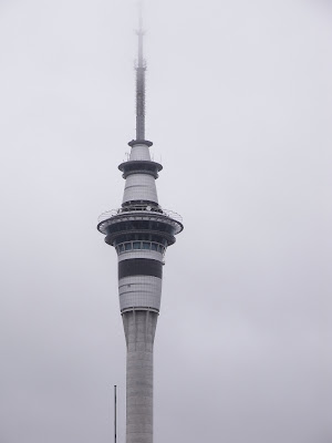 Sky Tower – the tallest building in the Southern Hemisphere

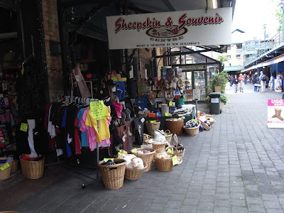 Victoria Park Market – there were not that many stalls
and things sold were nothing really special or exciting.
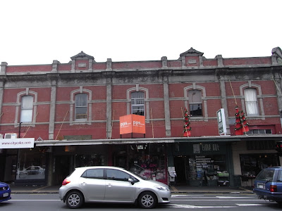
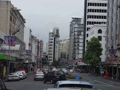
 Newmarket area (above and below)
With the gloomy weather and the wait, our extended holiday seemed to get on to a ‘bad’ start…
Finally we were told that one of the lights was not working and that they did not have spare units. We were given an alternate car (not equivalent of what we have paid for). We asked if there would be any compensation for all the inconvenience and was told that they would refund us for the first day rental. And they did. We were told that we could get the car (of what we had paid for) in the afternoon.
With that we drove off, heading for our motel. With the GPS, it was not difficult to locate it.
After checking in and having unloaded the luggage, we were all ready for some exciting time in Auckland and beyond. By then, the rain had stopped and things were beginning to look better and brighter. Our first stop was Mt Eden, followed by a visit to the Victoria Park Market.
While Mt Eden (Maungawhau) gave us a spectacular 360 degree superb view of Auckland, the Victoria Park Market was a let down.
(Auckland is punctuated by some 48 volcanoes and Mt Eden, at 196m, is the highest volcanic cone in the area.)
Mt Eden area (above and below)View from Mt Eden (above and below few)Harbour Bridge across the Waitemata Harbour in the backgroundThe crater at Mt EdenSky Tower – the tallest building in the Southern HemisphereVictoria Park Market – there were not that many stallsand things sold were nothing really special or exciting.
Newmarket area (above and below)Tongariro National Park
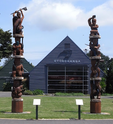
From Auckland, we travelled southwards to National Park, about 322km away. It is located on the fringe of Tongariro National park. En route, we stopped at a small town, Otorohanga for a short walk-about before proceeding to Waitomo Caves, about 16km from Otorohanga.
While there are many activities such as abseiling, rock climbing, rafting, cave tubing etc. which one can participate and there are also caves which are well known for its ‘colourful’ stalactites such as Aranui and Ruakuri Caves, we decided just to visit the Glowworm Cave. We first went through the usual assortment of (without the colourful artificial lighting) stalactites and stalagmites before taking a boat ride along the river. Surrounded by complete darkness, we were soon ‘blinded’ by the Milky Way of little lights – the glowworms – the pride of the cave.
The weather for the day was good. We were travelling along state highways 1, 39, 3 and 4. Initially certain stretches of the roads were slightly winding, while the later part was generally flat and straight.
Tongariro National Park is a World Heritage Site. Three great volcanic peaks dominate the park – Mt Tongariro (1,967m), Mt Ruapehu (2,797m) and Mt Ngauruhoe(2,287m).
Ruapehu, the highest point in the North Island, is one of the world's most active volcanoes and the largest active volcano in New Zealand. It is also the site of the country’s largest ski area. The summit erupted in 1966, blasting a massive amount of volcanic ash and steam into the air.
Ngauruhoe, unlike Ruapehu and Tongariro, is a conical, single-vent volcano.
We arrived at our lodge in the late evening. The motel was located literally in the middle of nowhere. For a few kilometers, we could see no other motels except ours. After checking in, we took a drive along state highway 47 heading towards Whakapapa Village (in Tongariro National Park). On the way, we saw the beautiful snow-capped mountains of Mt Ruapehu and Mt Ngauruhoe. We took the opportunity to take some photos of these famous mountains. Fortunately we did that as the following day, the weather took a drastic turn and that these mountains were heavily shrouded in the mist.
 Scenery along the State Highway (above and below)

 Otorohanga (above and below)
 Outside the Glowworm Cave, after the boat ride
 On the way to National Park
 Heading towards Whakapapa Village
 Mt Ruapehu
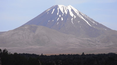 Mt Ngauruhoe
While there are many activities such as abseiling, rock climbing, rafting, cave tubing etc. which one can participate and there are also caves which are well known for its ‘colourful’ stalactites such as Aranui and Ruakuri Caves, we decided just to visit the Glowworm Cave. We first went through the usual assortment of (without the colourful artificial lighting) stalactites and stalagmites before taking a boat ride along the river. Surrounded by complete darkness, we were soon ‘blinded’ by the Milky Way of little lights – the glowworms – the pride of the cave.
The weather for the day was good. We were travelling along state highways 1, 39, 3 and 4. Initially certain stretches of the roads were slightly winding, while the later part was generally flat and straight.
Tongariro National Park is a World Heritage Site. Three great volcanic peaks dominate the park – Mt Tongariro (1,967m), Mt Ruapehu (2,797m) and Mt Ngauruhoe(2,287m).
Ruapehu, the highest point in the North Island, is one of the world's most active volcanoes and the largest active volcano in New Zealand. It is also the site of the country’s largest ski area. The summit erupted in 1966, blasting a massive amount of volcanic ash and steam into the air.
Ngauruhoe, unlike Ruapehu and Tongariro, is a conical, single-vent volcano.
We arrived at our lodge in the late evening. The motel was located literally in the middle of nowhere. For a few kilometers, we could see no other motels except ours. After checking in, we took a drive along state highway 47 heading towards Whakapapa Village (in Tongariro National Park). On the way, we saw the beautiful snow-capped mountains of Mt Ruapehu and Mt Ngauruhoe. We took the opportunity to take some photos of these famous mountains. Fortunately we did that as the following day, the weather took a drastic turn and that these mountains were heavily shrouded in the mist.
Scenery along the State Highway (above and below)Otorohanga (above and below)Outside the Glowworm Cave, after the boat rideOn the way to National ParkHeading towards Whakapapa VillageMt RuapehuMt Ngauruhoe The Journey to Rotorua
After a night stay in National Park, it was time to head back northwards – to Rotorua, about 200km away. But before we left, we went back to state highway 47 heading for Whakapapa Village and the mountain areas. We wanted to go as far as possible to have a good view of the park and the surrounding area.
We left the motel soon after 8:00am. It was drizzling and misty. We were hoping that the mist would clear up soon and so we continued…
Soon the flat, straight stretch of the road was behind us. Ahead, the road was getting steeper and more winding. As we ascended, the fog was getting thicker and thicker and visibility deteriorated drastically by the minutes. We decided to turn back when we could barely see a couple of meters ahead. I felt disappointed and dejected, but safety came first.
Not long after we left the national park region, the drizzle stopped and the sky brightened up. ‘We are going to have a great day after all,’ I thought to myself.
Our first pit stop was Opotaka, the site of the Maori village that was occupied in the 1800s. The second pit stop was Turangi. A small town located on the southern end of Lake Taupo. The town’s main attraction is its excellent trout fishing (on the Tongariro River).
The journey might be long, the road straight and monotonous at times, but it was also along this journey that we were ‘rewarded’ with the spectacular view of New Zealand’s largest lake, Lake Taupo.
Lake Taupo was formed by one of the greatest volcanic explosions of all time. Quote from Lonely Planet under the heading ‘Bang!’:
‘The Taupo region’s really big eruption was about 25,000 years ago – that was the one that actually created the huge basin now filled by Lake Taupo. The eruption produced an estimated 800 cubic kilometres of ash…’
 Opotaka (above and below 3)
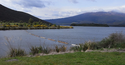 Lake Rotaire


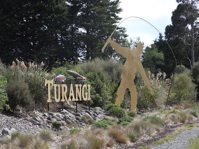 Turangi – well known for its trout fishing
 Turangi town (above and below)

 First sight of Lake Taupo. At 606 sq km,
it is New Zealand’s largest lake. It is also
proclaimed as the world’s largest trout fishing capital.
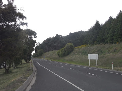 State highway 1, running parallel
to the eastern side of Lake Taupo.
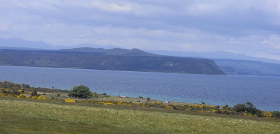 Lake Taupo (above and below)

 Our packed lunch. It is getting too expensive
to always eat at café or restaurants, so most of the days,
we had packed lunch – economical and save time too.
 More on Lake Taupo view
 Taupo town

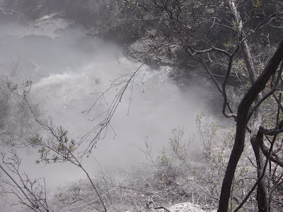
 Huka Fall (at Waikato River)
Known as Hukanui in Maori, meaning ‘Great Body of Spray’.
Water is clear and turquoise (above and below 3).


 The journey continued along state highway 5
 View from our motel in Rotorua.
Taken at 8:30pm (above and below).

We left the motel soon after 8:00am. It was drizzling and misty. We were hoping that the mist would clear up soon and so we continued…
Soon the flat, straight stretch of the road was behind us. Ahead, the road was getting steeper and more winding. As we ascended, the fog was getting thicker and thicker and visibility deteriorated drastically by the minutes. We decided to turn back when we could barely see a couple of meters ahead. I felt disappointed and dejected, but safety came first.
Not long after we left the national park region, the drizzle stopped and the sky brightened up. ‘We are going to have a great day after all,’ I thought to myself.
Our first pit stop was Opotaka, the site of the Maori village that was occupied in the 1800s. The second pit stop was Turangi. A small town located on the southern end of Lake Taupo. The town’s main attraction is its excellent trout fishing (on the Tongariro River).
The journey might be long, the road straight and monotonous at times, but it was also along this journey that we were ‘rewarded’ with the spectacular view of New Zealand’s largest lake, Lake Taupo.
Lake Taupo was formed by one of the greatest volcanic explosions of all time. Quote from Lonely Planet under the heading ‘Bang!’:
‘The Taupo region’s really big eruption was about 25,000 years ago – that was the one that actually created the huge basin now filled by Lake Taupo. The eruption produced an estimated 800 cubic kilometres of ash…’
Opotaka (above and below 3)Lake RotaireTurangi – well known for its trout fishingTurangi town (above and below)First sight of Lake Taupo. At 606 sq km,it is New Zealand’s largest lake. It is also
proclaimed as the world’s largest trout fishing capital.
State highway 1, running parallelto the eastern side of Lake Taupo.
Lake Taupo (above and below)Our packed lunch. It is getting too expensiveto always eat at café or restaurants, so most of the days,
we had packed lunch – economical and save time too.
More on Lake Taupo viewTaupo townHuka Fall (at Waikato River)Known as Hukanui in Maori, meaning ‘Great Body of Spray’.
Water is clear and turquoise (above and below 3).
The journey continued along state highway 5View from our motel in Rotorua.Taken at 8:30pm (above and below).
Wai-O-Tapu Thermal Wonderland
When one talks about South Island, one thinks of Mt Cook or Milford Sound. How about North Island? – the Maoris? Lake Taupo? Perhaps, but one other distinct ‘feature’ or attraction of North Island is of course its many volcanoes and the related features or activities.
Many of the thermal activities are found in and around Rotorua areas. In fact the nickname for Rotorua is ‘Sulphur City’ because of its distinctive, thermal, rotten-egg smell of hydrogen sulphide gas.
One can be spoilt for choice as to which thermal site / village to visit as there are so many. We settled for Wai-O-Tapu (Sacred Waters), about 30km south of Rotorua as this appears to be among the most popular one. It has a 3km walking trail which takes about 75 minutes to complete.
As one walks about taking in the spectacular view of the surrounding, admiring and wondering at how natures work, one would be ‘bombarded’ with – boiling and bubbling mud pools, gurgling hot springs, gushing geysers, pools with different hues (due to the different types of minerals), strong ‘uninviting’ smell. And occasionally steam would blur one’s vision (if one is wearing glasses).
 Wai-O-Tapu Thermal Wonderland Visitor Centre
 Mud pool – boiling and bubbling
 Lady Knox Geyser (above and below)
The geyser is induced to erupt daily at 10:15am
by dropping soap into the opening of the vent.
The jet of water can reach up to 20m high.

 Rainbow Crater
 Devil’s Ink Pot
 Artist’s Palette (above and below)


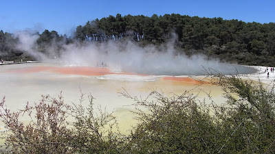
 Champagne Pool (above and below)

 Oyster Pool – a sulphurous pool
named after its distinct shape
 Sulphur Cave
 Lake Ngakoro
 Sulphur Mounds
 Sulphur Cave
 Devil’s Bath
Many of the thermal activities are found in and around Rotorua areas. In fact the nickname for Rotorua is ‘Sulphur City’ because of its distinctive, thermal, rotten-egg smell of hydrogen sulphide gas.
One can be spoilt for choice as to which thermal site / village to visit as there are so many. We settled for Wai-O-Tapu (Sacred Waters), about 30km south of Rotorua as this appears to be among the most popular one. It has a 3km walking trail which takes about 75 minutes to complete.
As one walks about taking in the spectacular view of the surrounding, admiring and wondering at how natures work, one would be ‘bombarded’ with – boiling and bubbling mud pools, gurgling hot springs, gushing geysers, pools with different hues (due to the different types of minerals), strong ‘uninviting’ smell. And occasionally steam would blur one’s vision (if one is wearing glasses).
Wai-O-Tapu Thermal Wonderland Visitor CentreMud pool – boiling and bubblingLady Knox Geyser (above and below)The geyser is induced to erupt daily at 10:15am
by dropping soap into the opening of the vent.
The jet of water can reach up to 20m high.
Rainbow CraterDevil’s Ink PotArtist’s Palette (above and below)Champagne Pool (above and below)Oyster Pool – a sulphurous poolnamed after its distinct shape
Sulphur CaveLake NgakoroSulphur MoundsSulphur CaveDevil’s Bath
Subscribe to:
Posts (Atom)
